LaCS
LaCS is a research project on sustainable urban mobility. The research is based on deciphering the movement patterns of citizens in the city to improve the urban physical space.
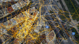
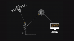
LaCS consists of a system for capturing the «invisible» urban dynamics left by mobile devices in the city of Valencia. To this end, an app was created that recorded the geolocation data of the participants-citizen residents for six months. These routes were visualised on a web interface (http://esgonau.webs.upv.es/trcp) through a series of graphic traces that were superimposed on the map of the real physical territory. The traces studied were colour-coded according to the different variables of mobility type, age and gender.
The resulting data helped to analyse the city in terms of sustainable mobility. The research concluded that 80% of the participants mostly travelled on foot for distances of less than 800 m and used public transport (bus or metro) or bicycle/scooter for longer distances within the city, and the car was only used for journeys outside the city. These findings were projected onto the fabric of the city, identifying possible areas for landscaping and pedestrianisation, proposing areas with a real need for cycle/pedestrian lanes and stops, and encouraging alternative proposals such as Car-Sharing for commuting to the suburbs.
Name:
LaCS
Typology:
Urban planning R&D
Location:
Valencia
Year:
2013
Research:
Regeneration and sustainable mobility
Institution:
Universitat Politècnica de València
Equipo:
Esther Gonzalez Aurignac, Tom Mossel, Marcos Pons, David Oliva